SEJournal Online is the digital news magazine of the Society of Environmental Journalists. Learn more about SEJournal Online, including submission, subscription and advertising information.
Reporter’s Toolbox: Making News When Your Ship (Tracker) Has Come In
By Joseph A. Davis
On the environment beat, ship-related ocean stories are many — oil spills, illegal fishing, agricultural trade … or all-out war.
So when the next environmental crisis breaks out on the water, are you ready to track it to the culpable vessels?
Today, with the help of satellites, the internet and the marketplace of data, journalists can get a ringside seat to the action when ships interact with the environment.
So you want some sea-worthy tools in your emergency kit? Toolbox has them here.
‘Secret sauce’ of ship-tracking
When modern weapons hit an oil tanker, there can be major environmental damage. Remember the “Tanker War” in the Persian Gulf in 1984 (actually, it was one of several).
These days, the prospect of Iran hitting tanker traffic in the Strait of Hormuz chokepoint seems suddenly more likely after hostilities with the United States escalated in late 2019-early 2020.
 |
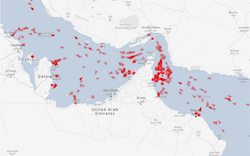
| Image: MarineTraffic. Click to enlarge. |
Want to show what that might look like? At right, as an example, is an image of the tankers in the Strait of Hormuz during the recent hostilities (the dots show ships at anchor, arrows show ships in motion).
When Toolbox originally saw this, it was a 24-hour animation from the day-of, and it was even more impressive. You may pull mapping tricks like this off with help from the wizards in your data and graphics shops (or by paying) (link may require subscription).
The penultimate source of this data was a commercial service called Visual Capitalist, which based it on images generated from another commercial service called MarineTraffic. This particular service claims to track virtually every major commercial vessel in the world.
Of course, there may be some limits and gaps, and it is really just one of several trackers. Yes, it costs money, but with a mid-level subscription, you get visual animations.
The secret sauce of these systems is what is
called the “automatic identification system,”
a kind of transponder that reports the
location and identity of commercial ships.
The secret sauce of these systems is what is called the “automatic identification system,” or AIS, a kind of transponder that reports the location and identity of commercial ships, often via satellite.
Because AIS data is available to anyone geeky enough to handle it and rich enough to afford good equipment, ship-tracking services are common and often free. Here is a list of eight good ones. You can get special apps for, say, military vessels or tourist cruise ships. You can even get trackers as an app on your smartphone.
To use these tools well journalistically, however, you have to get skillful with their specific features, like map layers and ship filters (that show just fishing vessels or oil tankers).
Learning how to use geographic information systems, or GIS, is an important sub-field of data journalism worth exploring, but beyond the scope of this Toolbox.
But here is a one-word note you might pass along to your editor: graphics! Ship trackers used skillfully (that means an investment of staff time) can produce eye-catching and illuminating graphics that will wake up whatever platform you are using.
An ocean of possible environmental stories
Of course, ship trackers can support environmental journalism beyond the next tanker war. Here are some ideas.
- Oil spills: Ships do discharge oil — accidentally or deliberately, legally or illegally. Ship trackers may just help trace some discharges to their source. Or build a list of suspects. The group SkyTruth used satellite imagery and AIS data to develop its original Oil Spill Tracker (now retired) for the Deepwater Gulf spill in 2010.
- Bilge, ballast and wastewater discharges: Trackers show ships, not discharges. But knowing a ship’s purpose and voyage can help draw inferences about discharges that may contain pollution or invasive species. SkyTruth has managed to catch some rogue dischargers.
- Fisheries: Illegal commercial fishing is a huge environmental story, but hard to cover. Ship-tracking has become one important way into it. For more, see Global Fishing Watch or Ian Urbina’s book, “The Outlaw Ocean.” Pro Tip: Watch for mischief when they turn the AIS off.
- Air pollution: Although pollution-control efforts are now afoot, ship engines produce a lot of conventional air pollution. The International Maritime Organization is trying to control it. Ship traffic concentrates in certain shipping lanes and port zones, where pollution may be worse.
- Species conflict: When ships strike whales, the whales get the worst of it. Efforts are now underway to slow and alert ships in areas where Atlantic right whales (among others) are present. Ship trackers may help you monitor this.
- Acoustic pollution: Many kinds of marine life are affected by noise pollution, of which ships are a significant source.
Joseph A. Davis is a freelance writer/editor in Washington, D.C. who has been writing about the environment since 1976. He writes SEJournal Online's TipSheet and Reporter's Toolbox columns. Davis also directs SEJ's WatchDog Project and writes WatchDog Tipsheet, and compiles SEJ's daily news headlines, EJToday.
* From the weekly news magazine SEJournal Online, Vol. 5, No. 5. Content from each new issue of SEJournal Online is available to the public via the SEJournal Online main page. Subscribe to the e-newsletter here. And see past issues of the SEJournal archived here.


 Advertisement


