


SEJournal Online is the digital news magazine of the Society of Environmental Journalists. Learn more about SEJournal Online, including submission, subscription and advertising information.
June 3, 2020

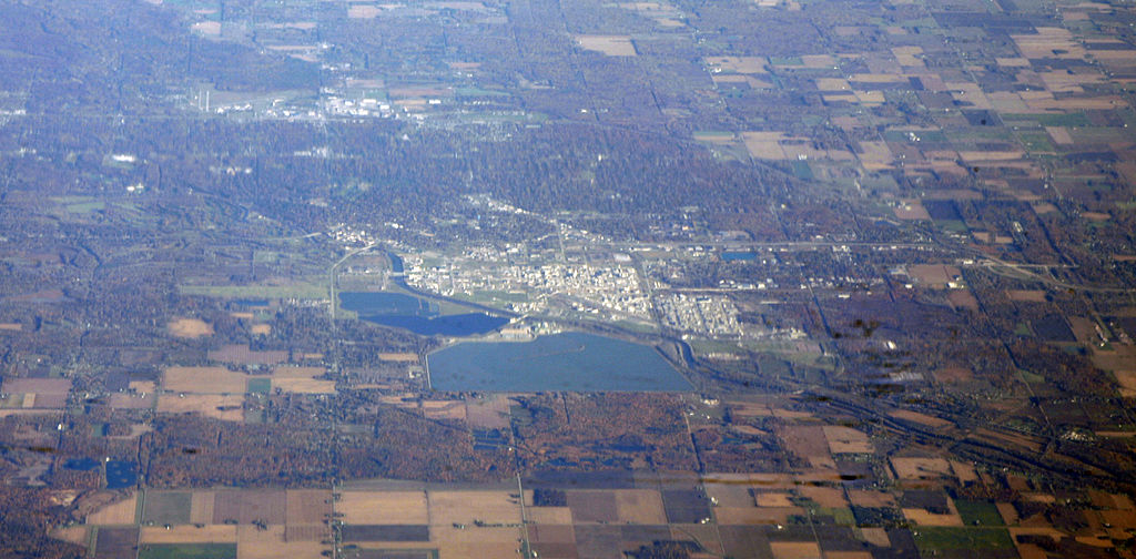 |
| Above, a 2010 aerial photo of Dow Chemical’s plant and headquarters, with brine ponds, in Midland, Mich. A complex cleanup of dioxin-tainted sediments at the site may have been upended by recent flooding. Photo: Doc Searls, Courtesy Wikimedia Commons. Click to enlarge. |
Reporter’s Toolbox: Using Data Sources To Track Climate-Driven Mayhem at Superfund Sites
By Joseph A. Davis
The unfolding flood disaster around Midland, Mich. (may require subscription), is a reminder that Superfund hazardous waste sites produce a variety of urgent environmental stories for local reporters to keep an eye on.
Wherever you are, there is probably a Superfund site near you. Nationwide, there are some 1,335 sites on the Superfund National Priorities List, or NPL, in various stages of cleanup. And there are more that are not on the NPL list. Your state may have its own list.
If there is no news there, either you are lucky or you are not trying.
The 1980 Superfund law (CERCLA) has evolved. It is a complicated subject that keeps many lawyers employed. But right now, think of your local Superfund site potentially as an imminent disaster.
Midland at center of chemical empire
At Midland, they thought they had the disaster thing under control. They were wrong.
Midland, starting way back in 1897, was the center and headquarters of the massive chemical empire that became Dow Chemical. The idea was to extract brine from vast underground salt formations and, from sodium chloride, build a whole world of industrial chemistry based on chlorine.
But in the process, over many decades, Dow discharged into the Tittabawassee River chemical wastes that polluted sediments with dioxins, a highly toxic class of chemicals that can disrupt the human endocrine and immune systems and can cause cancer.
The mess stretched for some 50 miles downstream. A complex cleanup, begun in 2007, was almost finished … when the latest floodwaters swamped and roiled the site, possibly remobilizing much of the sediment. Coming weeks will tell.
Many Midlands?
The Midland flood is a special example of a more widespread problem. The “cleanups” at Superfund sites (when finished) do not necessarily make hazardous pollutants vanish.
Instead, often, the pollutants are just moved to a different location or immobilized in a landfill. Though meant to be as permanent as possible, those solutions are not invulnerable.
The idea of floods, wildfires, hurricanes, storm surges,
sea level rise and other earthly upheavals setting loose
the hazardous wastes at Superfund sites is not far-fetched.
The idea of floods, wildfires, hurricanes, storm surges, sea level rise and other earthly upheavals setting loose the hazardous wastes at Superfund sites is not far-fetched.
The nation learned this in the Houston area after Hurricane Harvey in 2017. The stalled storm dumped an unimaginable amount of rain (40+ inches) in places — one of which was the San Jacinto River Waste Pits Superfund site.
Associated Press crack investigative reporters wrote a story about flooding at that site and six others around Houston. EPA (back then just beginning to invent “nasty-grams”) inaccurately attacked the AP story for inaccuracy, then confirmed it and then disclosed some other Houston-area Superfund sites that had been inundated.
The incident was one inspiration for Senate Democrats to seek an investigation by the Government Accountability Office. The resulting GAO report found that 945 of 1,571 Superfund sites studied were vulnerable to flooding and other climate-related disruptions.
And, as a gift to environmental reporters across the United States, GAO put the list of sites into a publicly available database, so they could do their own stories. The database is available in spreadsheet form (an XLSX file which includes a data dictionary) and in CSV form.
Using the data
The starting point, once you get the data loaded into your spreadsheet, is to find sites in your state or area of interest.
Once you discover sites of interest, you can learn more about them by going to EPA’s much larger store of data on sites in the NPL.
It is hard to generalize about Superfund sites — and what can go wrong with them. Some general guidance: Remember that most sites still on the NPL have not yet been fully cleaned up. That means that some of the hazardous materials may not yet be in their final, “stable” location and will therefore be more vulnerable to dislocation.
Often the chemicals of concern at a site will have been mixed with soil or river sediment. When the hazardous chemicals are remobilized by water, wind, fire or some other cataclysm, they can become threatening again.
Watch a few horror movies and then use your imagination.
Here’s one nightmare scenario: This spring the area around the melted-down Chernobyl nuclear reactor in Ukraine was beset by climate-related wildfires (may require subscription). The worry was that radioactive materials could be spread.
This may go beyond the scope of the GAO project or of the Superfund, but not beyond the realm of possibility: Similar concern was prompted during the Cerro Grande fire near the Los Alamos National Laboratory in 2000 and the Las Conchas fire there in 2011. Ultimately, significant radiation release did not materialize.
Contaminated soil susceptible to floods, sea level rise, surges
Just to jog your imagination, some Superfund sites involve material that is spread out over a considerable area (take, for example, the Tar Creek site in Oklahoma). It may be waste from mining or deposits from a heavy metal smelter.
Floods or big precipitation events can move that contaminated soil to places that can harm people. But don’t ignore the possibility of a dust storm or tornado just because the GAO did not include it in the report.
While climate-related sea level rise is a convenient villain, don’t underestimate the power of storm surges, which are already happening in many coastal areas.
If you have coastal Superfund sites in mind, check out the National Storm Surge Hazard Maps produced by the National Oceanic and Atmospheric Administration. Or, if you are not looking at the coast, explore the FEMA Flood Map Service Center.
Finally, yes, catastrophic dam collapse and inundation is possible in many places. And not just upstream of Superfund sites but, in at least one case, upstream of an operating nuclear power plant (e.g., the Oconee nuclear plant in South Carolina).
A starting point for exploration is the National Inventory of Dams or one of the other dam databases. Or contact the Associated Press for even better data from their dam safety data project.
Joseph A. Davis is a freelance writer/editor in Washington, D.C. who has been writing about the environment since 1976. He writes SEJournal Online's TipSheet, Reporter's Toolbox and Issue Backgrounder, as well as compiling SEJ's weekday news headlines service EJToday. Davis also directs SEJ's Freedom of Information Project and writes the WatchDog column and WatchDog Alert.
* From the weekly news magazine SEJournal Online, Vol. 5, No. 22. Content from each new issue of SEJournal Online is available to the public via the SEJournal Online main page. Subscribe to the e-newsletter here. And see past issues of the SEJournal archived here.
SEJ Publication Types:
Topics on the Beat:
Region:
Visibility:

