SEJournal Online is the digital news magazine of the Society of Environmental Journalists. Learn more about SEJournal Online, including submission, subscription and advertising information.
 |
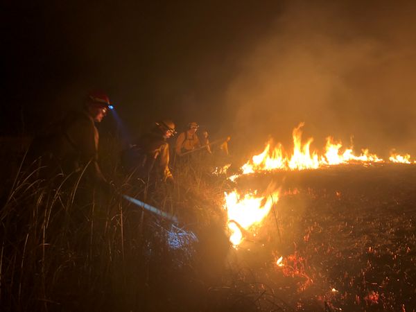
| Drought brings elevated wildfire risk, and hot, dry conditions in states like Florida have meant wildfires are already underway. Above, firefighters fighting the so-called “Sunday Afternoon” fire, which burned 1,400 acres just south and east of the Everglades National Forest in April. Photo: National Park Service/Michael Gue. Click to enlarge. |
Reporter's Toolbox: No Drought of Data, As Climate Dries U.S.
The wildfires are already burning in Florida, the dry season is coming soon to much of the rest of the United States and, with the advent of climate change, a once-routine yearly event is all too often now a once-in-a-lifetime disaster story.
Fortunately, there’s a lot of data to help environmental journalists cover it.
Recent headlines have warned that the Western United States is already suffering a “megadrought” of historic proportions, supercharged by climate change.
California, which withered under a devastating drought during 2011-19, has recently experienced cataclysmic wildfires (such as the Camp Fire of 2018). This year, when scientists went out to measure the Sierra snowpack, they found it skimpy, which is bad news, because it augurs another drought year.
While disasters grab headlines, drought (and floods) can generate a lot more routine news: crop reports, irrigator lawsuits, shipping problems, stressed forests and insurance upsets. Having a sound data foundation can help you cover whatever aspect you are focused on.
U.S. Drought Monitor — a key data source
Drought nerds have probably already bookmarked the U.S. Drought Monitor on their browsers. And they check it often.
Every week, the U.S. Drought Monitor generates a set of reports based on an amalgam of the best data, presented in text and map form. And the graphics are public domain (give credit). Take a look at it here.
The drought monitor is hosted at the University of Nebraska-Lincoln (Nebraska is one of the drier places on the continent, with lots of farms).
Partners in the enterprise include the National Oceanic and Atmospheric Administration, or NOAA, which runs most of the Earth-observing satellites that generate the moisture data. Another partner is the U.S. Department of Agriculture, which has a big stake not only in anticipating droughts but in dealing with them when they become disastrous for farmers.
The university also hosts the National Drought Mitigation Center, a team of experts in dealing with drought.
If you are writing for a regional or local audience, it is worth exploring the Drought Monitor well before the cattle start dying and the grassfires begin. You can zoom down to regional-scale maps that give a lot of detail.
Other drought data resources
Drought, as the experts define it, is more than just a lack of rain or snow. It is characterized by persistence and that eventually means dry soil. Soil moisture is a measure of drought. Sometimes lack of soil moisture worsens lack of rainfall.
So you might want to seek out data products from the National Soil Moisture Network. This is a huge collaboration of federal agencies, states and research institutions. It is a work in progress. And — don’t say we didn’t warn you — it gets very technical.
Since drought is, at the bottom, a lack of water,
data on water and precipitation also bear
heavily on the situation. The USGS is perhaps
the foremost federal agency looking at water quantity.
You can get an overview of its soil moisture map products here. It is organized under the wider auspices of the National Integrated Drought Information System.
Since drought is, at the bottom, a lack of water, data on water and precipitation also bear heavily on the situation. The U.S. Geological Survey is perhaps the foremost federal agency looking at water quantity.
Essential to this picture is the USGS national network of gages measuring streamflow at many points. This produces a massive historical database, as well as great maps.
USGS has a capable and flexible query system that allows you to generate custom reports and maps. The data on this system are very fast, or, as they say, “near real-time.”
Several sub-agencies within the empire that is NOAA also have data relevant to drought.
One important dimension of drought studies is being able to predict it. NOAA is good at predicting; after all, they do have the National Weather Service, or NWS. But even more helpful on this is the NOAA Climate Prediction Center (which is under the NWS).
The Climate Prediction Center’s special wizardry is in tracking the El Niño/Southern Oscillation, or ENSO, phenomenon, which strongly influences weather on timescales of months-to-years, and is key in predicting drought. It publishes a Seasonal Drought Outlook in map form, which we found here. There’s also a monthly outlook and predictions on other timescales. It also does a good soil moisture map of its own.
The USDA’s Natural Resources Conservation Service has a network of state and local offices that may provide further information. You might also be wise to check in with your state water resources agency, state agriculture agency and county extension for more info.
* From the weekly news magazine SEJournal Online, Vol. 5, No. 20. Content from each new issue of SEJournal Online is available to the public via the SEJournal Online main page. Subscribe to the e-newsletter here. And see past issues of the SEJournal archived here.


 Advertisement


