


SEJournal Online is the digital news magazine of the Society of Environmental Journalists. Learn more about SEJournal Online, including submission, subscription and advertising information.
March 6, 2019
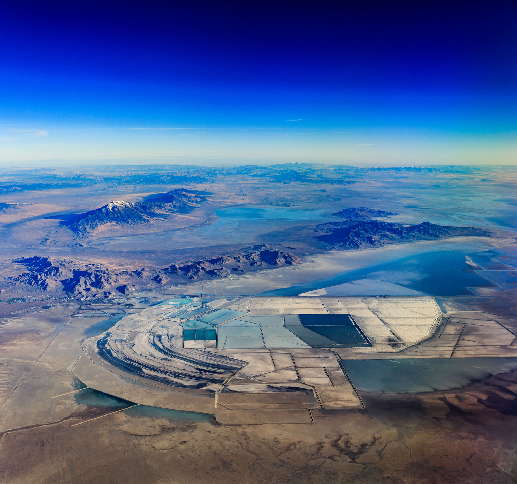 |
| The Great Salt Lake Desert in Utah, one of a series of unique, experimental aerial panoramas taken by the author. Photo: Dennis Dimick. Click to enlarge. |
EJ InSight: Capturing a Planet on the Fly
By Dennis Dimick
When I was twelve, an early self-assigned project was building a map collection of every U.S. national forest. My career goal then was to become a forest ranger, fire lookout or smokejumper, and I wrote letters to all 150-plus forests requesting maps so I could get a lay of the land.
For months, our mailbox was filled with map-stuffed envelopes. I’m not sure where those maps are now, but it’s fair to say that making sense of our world through maps, atlases and pictures has been a lifelong obsession.
The forest career didn’t pan out. I bought a camera in college, and nearly four decades ago as a young National Geographic picture editor it was my good fortune to collaborate with famed Swiss aerial photographer Georg Gerster on a book project about world deserts.
Gerster had recently published “Grand Design: The Earth from Above,” and his aerial pictures, as well as newly available NASA Landsat satellite images, introduced me to the wonder of looking at Earth from above.
Ever since, inspired by Gerster, I’ve always tried to sit by airplane windows to look out when flying. My archives brim with pictures taken from the air.
A fresh perspective with multi-image panoramas from above
Since moving from film to digital cameras, I’ve been creating panoramic images of scenes on the ground by merging a series of images into a single picture.
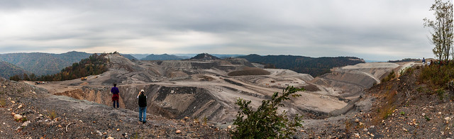
In October 2008, for instance, while on a Society of Environmental Journalists’ conference tour to mountaintop removal coal mines, we visited Kayford Mountain in West Virginia, where I created a panoramic image from 27 separate exposures. The picture vividly reveals the damage of surface mining in ways a single image never could.
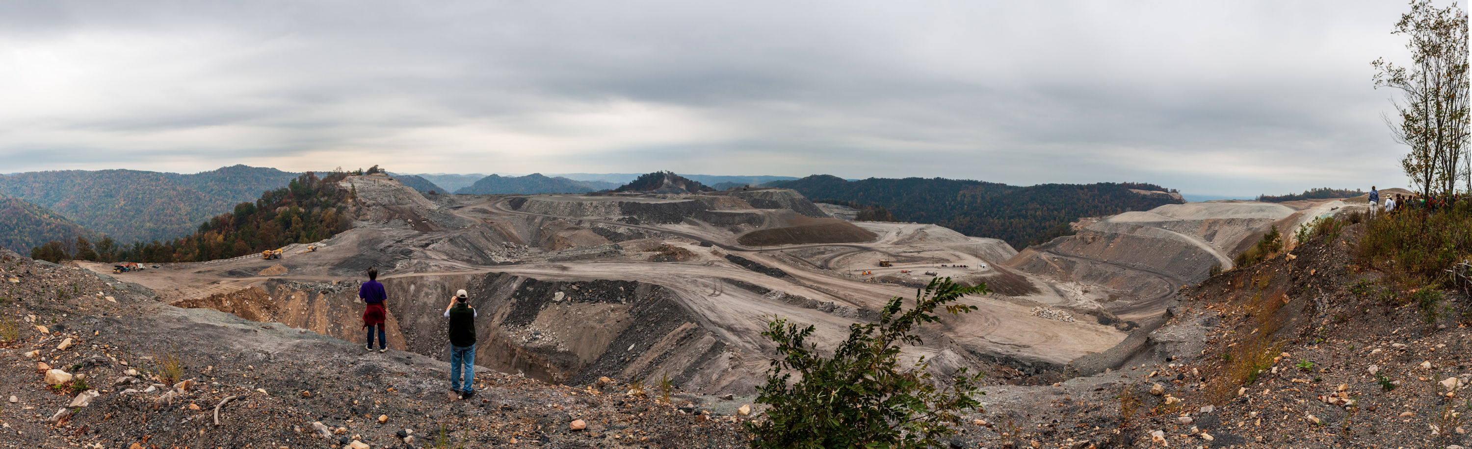 |
| Kayford Mt., W.V., Oct 2008. Photo: Dennis Dimick. Click to enlarge. |
The connection between my land panoramas and what I could achieve from the air was never obvious, as I mistakenly assumed that shooting multi-image panoramas while moving at 500 miles an hour wouldn’t work.
But over the years frustration grew with my images from airplanes, as most of the single pictures — whether telephoto or wide angle — felt cramped and small, inadequate to the epic expanses passing below.
These first ‘on-the-fly’ experiments
revealed the untapped potential
of aerial panoramas.
This changed enroute from Los Angeles to Washington in June 2014, as urban development in California’s Coachella Valley and natural gas fracking in the Texas Panhandle passed below. These first “on-the-fly” experiments, combining two images with slightly different framing taken within a second, revealed the untapped potential of aerial panoramas, and remain favorites.
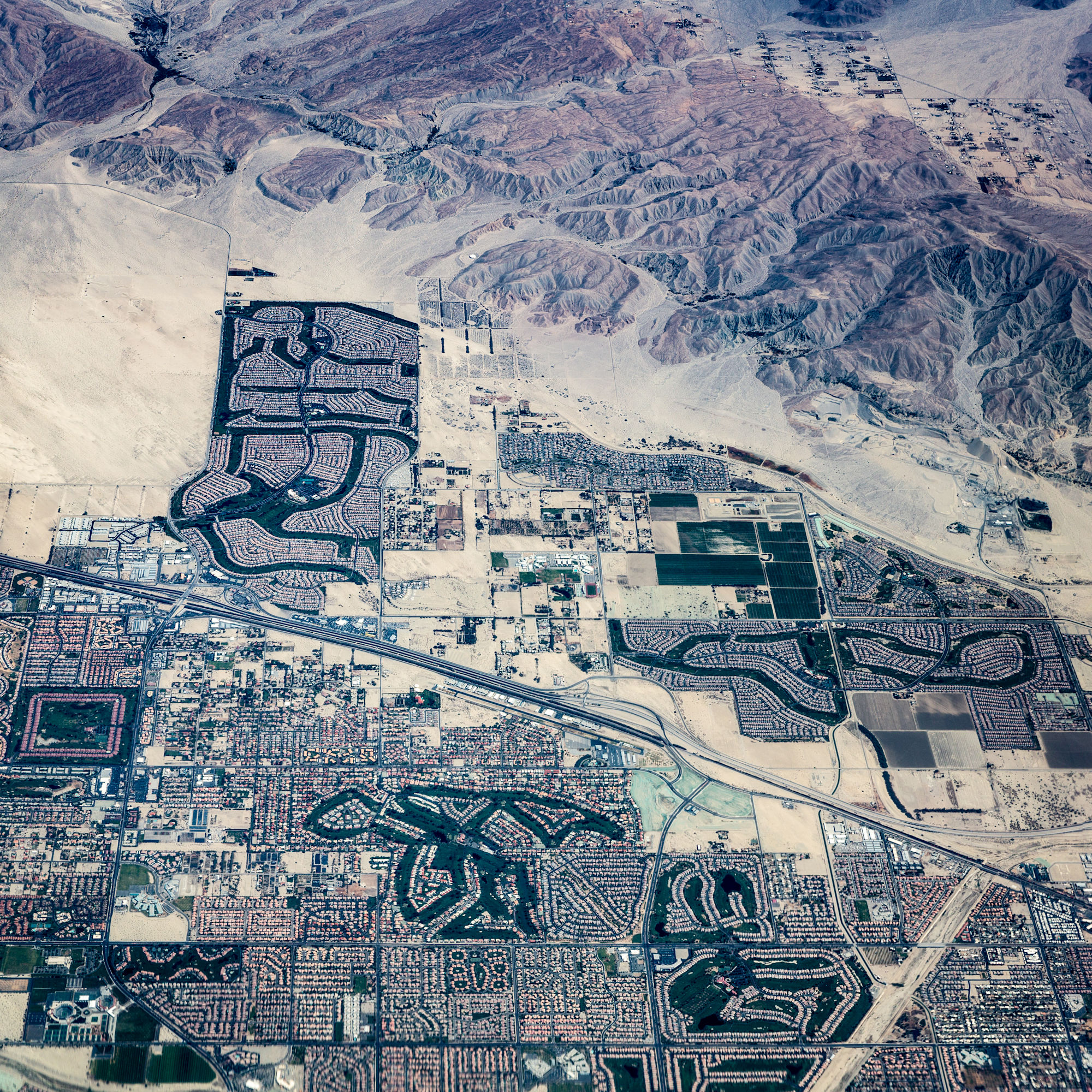 |
| Bermuda Dunes, Calif., June 2014. Photo: Dennis Dimick. Click to enlarge. |
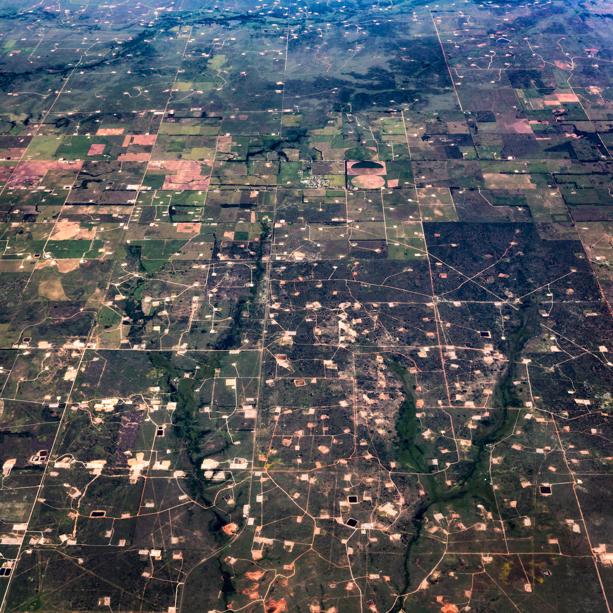 |
| Fracking at Allison, Texas, June 2014. Photo: Dennis Dimick. Click to enlarge. |
Since then I’ve shot panoramas on nearly every flight. My focus has been landscape transformation: suburban development at urban edges, irrigated and dryland crop farming, coal and hardrock mining, dams and reservoirs, logged and burned forests.
This growing set of images visualizes the emergent Anthropocene era, or Human Age, showing our expanding human footprint.
On passenger airplanes, capturing pictures ‘at the edge’
The late photographer Galen Rowell told me his most interesting pictures were found at the edge. He meant the edge between forest and savanna, between land and water, between day and night, and between the seasons.
I’m always mindful of Rowell’s words, seeking pictures that reveal the edge between humans and nature, between managed and shrinking natural landscapes.
Passenger airplane routes are fixed, but one advantage is the variety of scenes and visual possibilities that pass by in just a few hours.
Personality of scenes changes from season to season, as does air quality. I’ve flown the Washington-San Francisco route so often I recognize what state I’m over by looking out the window.
Winter typically offers clear air, but snow likely covers the ground in midwest and mountain states. A dusting of snow makes for interesting pictures, as does early and late sunlight.
Summer air is usually hazy or smoky; the east has its coal-fired power plants and cities, while western states suffer a rising frequency of forest fires.
I’ve found spring and fall generally good times for aerials, as plants are either in fresh spring green or in autumn hues.
Weather determines success, as clouds sometimes block ground views for a whole flight. Because of cloudiness, I’m still trying to get a clear panorama of several mountaintop mines in West Virginia, seen to the west on the Washington-to-Houston route.
Sitting on the side of the plane away from the sun produces the clearest pictures, but plastic layers in airplane windows degrade image quality. In general, newer and larger planes have cleaner window plastic.
Tools, tips and ‘location’ challenges
While digital single lens reflex cameras are my main tool, it’s possible to get good quality phone images and pictures from point-and-shoot cameras. In general what you find each time surprises, but success requires constant watching.
Interesting pictures with stronger foreground elements are possible when airplanes are below cruising altitude in the minutes after takeoff or before landing (something made possible only a few years ago when the FAA finally allowed use of small electronic devices — like cameras — at the start and end of flights).
Typically the hardest part
is identifying exact scene locations.
I’ll often spend hours trying to match
pictures with latitude-longitude locations.
Typically the hardest part is identifying exact scene locations. I’ll often spend hours trying to match pictures with latitude-longitude locations on Google Earth, a satellite image database showing virtually all of Earth’s land surface.
While newer digital cameras include GPS tracking, this usually doesn’t work inside airplanes. But iPhones often track location even while in airplane mode, and I’ll parallel-shoot with my phone just to get location data for later comparison to images from digital SLRs.
A phone app called Flyover Country, which tracks with GPS, can also aid identification of ground locations with a built-in map of your route.
Experimenting with ground-level panoramas
In about five years of work I’ve created panoramas from across the continent.
To name a few, clearcut forests in Oregon and Washington, salt ponds in Utah’s Great Salt Lake Desert, expanding suburbs near Denver and Chicago, and images of the checkerboard mile-square survey grid of U.S. western lands that encouraged westward migration and settlement.
I keep working to improve ground-level panoramas too, trying variations to create a high-definition look more commonly seen in medium- or large-format images.
During the 2017 SEJ conference in Pittsburgh, I created panoramas during the fracking tour, taking several images of a scene with a 35mm wide-angle, then stitching them together in software (see sidebar for details).
These multi-image pictures offer a wider view without suffering the perspective distortion of wide-angle lenses.
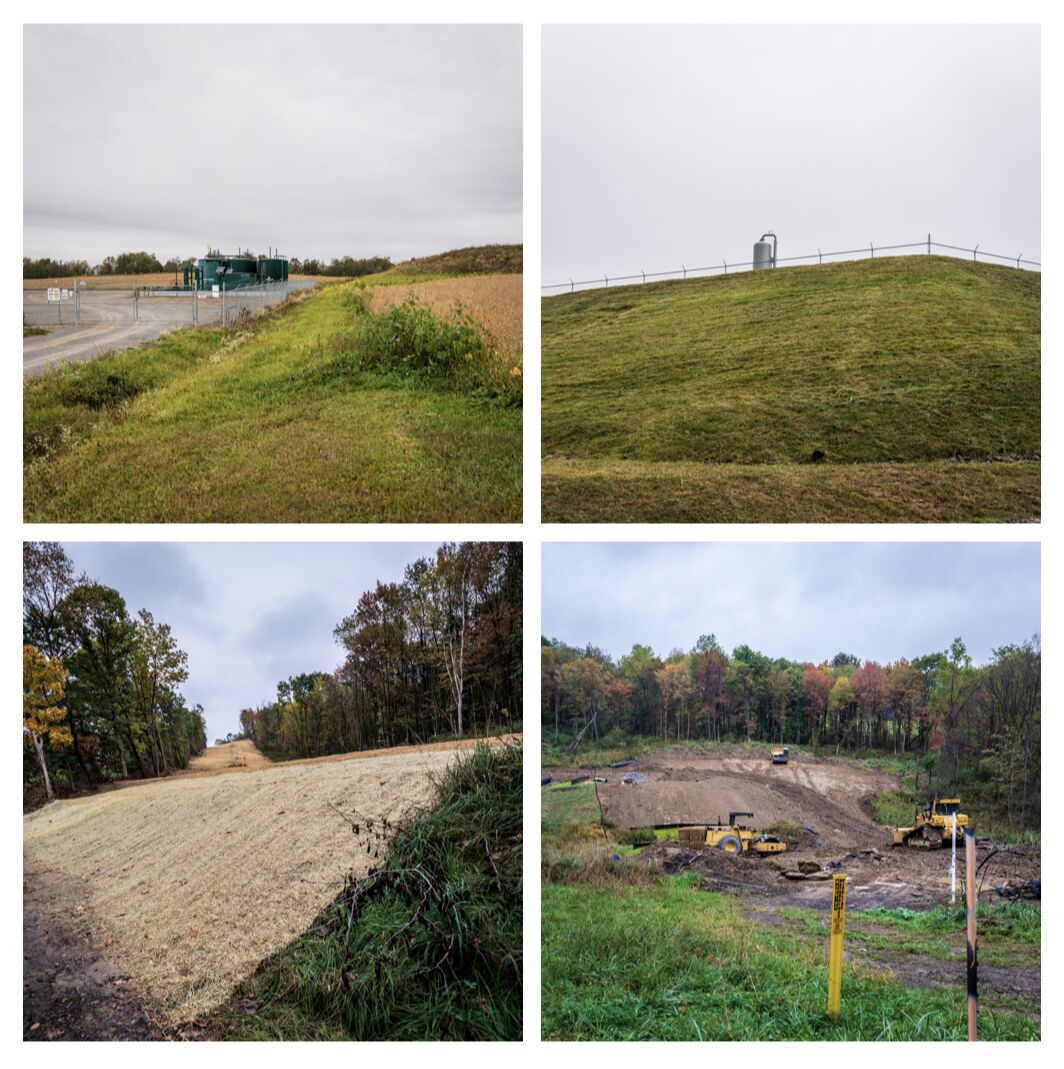 |
| Scenes from natural gas fracking facilities during an October 2017 SEJ tour. Photo: Dennis Dimick. Click to enlarge. |
In general, the whole project is an experiment. I’m trying new ways of doing this each time, whether in the air or on the ground.
Panoramic views reveal a fresh perspective, short of hiring airplanes at great expense for custom photography flights. Of course that would allow perfect timing, choice of weather and altitude, but that’s not in the budget. (There is no budget.)
It’s a fun challenge creating images from passenger airplanes — an overlooked vantage point — that offer a more encompassing perspective than possible with single frame views.
‘Height provides an overview,
and an overview facilitates insight.’
— Aerial photographer Georg Gerster
In 2017 I traveled to Switzerland to visit Gerster, who first inspired my aerial photography quest, and showed him several aerial panoramas.
Gerster, who had spent his whole career shooting single frame aerials with film, said, “I’ve never seen anything like this before. These should be in a book.”
Sadly as I wrote this piece, news arrived that Gerster passed away on Feb. 8, 2019, at age 90.
But his guiding philosophy remains: “Height provides an overview, and an overview facilitates insight, while insight generates consideration — perhaps.”
Editor’s Note: See the related sidebar, “EJ InSight: Perfecting Your Panorama Technique.” And for more of Dimick’s images in full size, visit his Flickr page here, or view the Flickr album below.
Society of Environmental Journalists board member Dennis Dimick served as National Geographic’s environment editor for more than a decade. He is a 21-time Missouri Photo Workshop faculty member, and is co-founder of EyesOn.Earth, a project to inspire a new generation of environmental photographers. He received the Charles M. Sprague Memorial Award in 2013 from the National Press Photographers Association for service to photojournalism.
* From the weekly news magazine SEJournal Online, Vol. 4, No. 10. Content from each new issue of SEJournal Online is available to the public via the SEJournal Online main page. Subscribe to the e-newsletter here. And see past issues of the SEJournal archived here.
SEJ Publication Types:
Topics on the Beat:
Region:
Visibility: